
8 Fascinating National Parks in Croatia
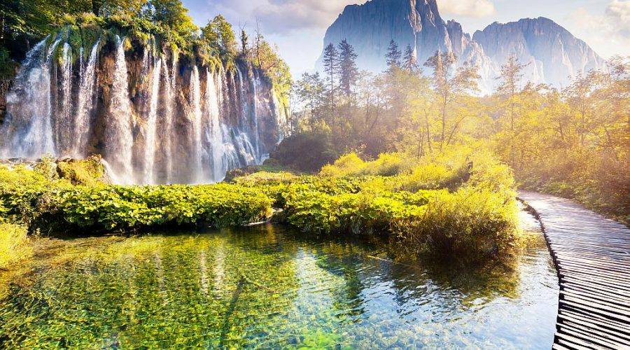
Plitvice Lakes National Park
Plitvice Lakes National Park is one of eight Croatian National Parks. It is the most popular National Park in Croatia and it is on the list of UNESCO World Heritage Sites. The park is famous for its chain of lakes arranged in cascades with 16 lakes divided into two groups, upper and lower lakes divided by a long lake Kozjak. The length of connected lakes is over eight kilometers and the park covers an area of almost 300 square kilometers. The water exiting from the last lower lake forms the Korana river.
Lakes are connected by amazing waterfalls and cascades. The biggest waterfall called “Veliki slap” is 70 m tall. During the centuries the water has flown over the natural limestone, creating these wonderful bigger and smaller lakes by the process of tufa development. The lakes are separated by the natural dams and travertine barriers and over some barriers, you can walk the wooden paths between the lakes and admire this beauty of nature. Its trademark is the brown bear and Plitvice Lakes are home to many animal species and many unique protected plant species.

[vc_row widthopt=”” fixedbg=”” footerrow=””][vc_column][vc_btn title=”Plitvice on Map of Croatia” color=”sky” align=”center” i_icon_fontawesome=”fa fa-map-o” add_icon=”true” link=”url:/listing/plitvice-lakes-national-park/|title:Plitvice%20Lakes%20on%20map%20of%20Croatia||”][/vc_column][/vc_row]
Brijuni National Park
Brijuni Islands (Brionian Islands) are a group of fourteen small islands in northern Adriatic, separated from the west coast of the Istrian peninsula by the Fažana Strait. The largest island is Veliki Brijun Island and it kilometers off the coast. Popular for their impressive beauty, the islands are a famous holiday resort and a Croatian National Park. Flora on the islands has typical Mediterranean characteristics and there are more than 600 indigenous plant species. The islands have also a rich fauna, many autochthonous species (Istrian ox, sheep, donkeys, and goats) and many other imported and acclimated. There is also a Safari Park on the island od Veliki Brijuni, home to a variety of exotic animals, many of them donated as gifts from Croatian diplomatic partners like the Asian elephant and zebu from India. The island has another interesting particularity, as it is home to four sites with over 200 dinosaur footprints from the last period of the Mesozoic Era, absolutely worth visiting.

On the islands, there are also other sites worth seeing, such as the ruins in Verige Bay are possible remains of the imperial Roman summer residences of 1st century A.D, well-preserved remains of St. Mary’s basilica from the 5th century and of a small church of St. Peter from the 6th century, two ancient Roman villa remains, from the 2nd Century BC and remains of a Byzantine palace. Visit also the Hill’s Fort, fortified Bronze Age settlement with preserved walls, entrance and necropolis, situated on a small hill near the Verige Bay.

[vc_row widthopt=”” fixedbg=”” footerrow=””][vc_column][vc_btn title=”Brijuni on Map of Croatia” color=”sky” align=”center” i_icon_fontawesome=”fa fa-map-o” add_icon=”true” link=”url:/listing/brijuni-national-park/|title:Brijuni%20on%20map%20of%20Croatia||”][/vc_column][/vc_row]
Kornati National Park
Kornati islands, also called Stomorski islands are located in northern part of Dalmatia, west of the city of Šibenik and east of the city of Zadar. Kornati islands occupy a sea area of around 320 square kilometers and are divided into two main groups – Upper and Lower Kornati. There are no permanent settlements on the islands and 89 of 140 islands were declared a national park in 1980. The area covered by the National Park principally coincides with the Upper Kornati, which includes the biggest island of the archipelago Kornat and the surrounding islets. It is a perfect place for numerous activities like sailing, snorkeling, diving, swimming, hiking, observing the plant and animal wildlife. The park is managed by the town of Murter, on the island of Murter.

Kornati islands can be reached by organized tours or by your own boat. Anchoring and spending the night in the Park is allowed only at 16 locations and camping is rigorously forbidden outside the authorized campsites. There are several restaurants and boats that cruise around the national park selling food and basic supplies during the high season.

Interesting fact: The names of the islands Babina Guzica and Kurba Vela, which in Croatian refer to Granny’s Butt and Big Prostitute, are some of the vulgar names given to Kornati islands and islets when Austrian surveyors came to record the archipelago in the 19th century and their local guides mocked them by making up vulgar names for the various locations.
[vc_row widthopt=”” fixedbg=”” footerrow=””][vc_column][vc_btn title=”Kornati on Map of Croatia” color=”sky” align=”center” i_icon_fontawesome=”fa fa-map-o” add_icon=”true” link=”url:/listing/kornati-national-park/|title:Kornati%20on%20map%20of%20Croatia||”][/vc_column][/vc_row]
Krka National Park
Krka National Park is named after the river Krka that it encloses. It is located in central Dalmatia, near the city of Šibenik and it was proclaimed a national park back in 1985. The Krka National Park is a vast, mainly unchanged region of extraordinary natural value and includes many preserved or insignificantly altered ecosystems. Skradinski Buk waterfall is one of two main waterfalls on Krka river, although there are seven amazing waterfalls on Krka river. It is the lowest and the longest one. Skradinski Buk is considered one of the most beautiful calcium carbonate waterfalls in Europe due to its richness in geomorphological forms, ecosystem and numerous impressive light effects in the whirlpools.

Roški Slap is the second main waterfall on Krka river, particularly appealing due to its cascades. There is a road over the waterfall which dates back to Roman times. One of the main attractions other than the waterfalls is a small island of Visovac, which is home to a Catholic Monastery founded by Franciscans back in 1445. There are numerous facilities available like souvenir shops, museums, bars, and restaurants. National Park has five entrances, but there are the two main entrances at Skradinski Buk and Roski Slap. For those who come by car, there is a free parking nearby the entrances.

[vc_row widthopt=”” fixedbg=”” footerrow=””][vc_column][vc_btn title=”Krka on Map of Croatia” color=”sky” align=”center” i_icon_fontawesome=”fa fa-map-o” add_icon=”true” link=”url:/listing/krka-national-park/|title:Krka%20on%20map%20of%20Croatia||”][/vc_column][/vc_row]
Mljet National Park
One od the most spectacular national parks in Croatia is situated on the island of Mljet in the south of Croatia. National park Mljet will offer you a scenery that will remain imprinted on your mind forever. It is a perfect place for those in search of a unique experience. The National park occupies the surface of almost a third of the island, stretching over 5400 hectares and including a marine area of around 500 meters from the coast. It is home to a particularly rich flora nad fauna, but also to an important cultural heritage as there are numerous archeological finds that will delight all the history lovers. There are two saltwater lakes, Veliko and Malo Jezero (Large and Small lake) that stretch for more than 4 km. Both lakes are encircled by shaded paths where you can stroll or cycle, enjoying the amazing scenery in the best possible way.

There is a small island Sv. Marija (The Isle of Saint Mary) in the middle of the Large lake and it is home to a former 12th-century Benedictine monastery, now turned restaurant. You can easily get to the small island by boats that sail from both sides of the Large lake. There are two villages from which the park can be entered – Polače and Pomena, although there is no official entrance, these are the ones where you can buy the tickets, get the brochures and maps. Pomena is just 10 minutes walk from Malo Jezero and 20 minutes walk from Mali most (Small bridge) where you can take a boat to Sv. Marija islet. Polače is about 45 minutes walk away from Malo jezero. No vehicles are allowed in the park, you can rent a car to drive along the part of the island that isn’t a part of the National park.

[vc_row widthopt=”” fixedbg=”” footerrow=””][vc_column][vc_btn title=”Mljet on Map of Croatia” color=”sky” align=”center” i_icon_fontawesome=”fa fa-map-o” add_icon=”true” link=”url:/listing/mljet-national-park/|title:Mljet%20on%20map%20of%20Croatia||”][/vc_column][/vc_row]
North Velebit National Park
North Velebit National Park covers 109 km2 of the northern section of the Velebit mountain, the largest mountain in Croatia. On the southern side of the mountain there is Paklenica Nationa Park, so practically the whole of the Velebit mountain is a nature park. It is recognizable by its conserved biodiversity, the abundance of the natural phenomena and experience of pristine wilderness. A surprising abundance of vegetation and natural beauty can be found in this national park, especially in the Zavižan-Balinovac-Velika kosa botanical reserve, famous for its outstanding collection of species of mountain flora. The park reserve is protected and visitors cannot pass through except on assigned trails. The Park is crossed with numerous mountaineering trails and one of the most popular is the Premužić’s Trail, which leads you through the most interesting parts of the park.


[vc_row widthopt=”” fixedbg=”” footerrow=””][vc_column][vc_btn title=”North Velebit on Map of Croatia” color=”sky” align=”center” i_icon_fontawesome=”fa fa-map-o” add_icon=”true” link=”url:/listing/north-velebit-national-park/|title:North%20Velebit%20on%20map%20of%20Croatia||”][/vc_column][/vc_row]
Paklenica National Park
Paklenica is located near Starigrad in northern Dalmatia, at the southern slopes of Velebit mountain. The name Paklenica probably derives from black pine sap called “paklina”, which the locals used in traditional medicine, for wound treatment, for light and for coating of wooden boats. It was proclaimed protected area back in 1949 and as a national park in 1997. The most attractive parts are two canyons, Small and Big Paklenica.

Paklenica National Park is almost entirely explored in terms of speleology and it has 76 speleological locations (pits and caves). It is also the most visited climbing site in Croatia and the largest one in Southern Europe. Hiking and climbing are really the only two ways to get to know impressive and unspoiled nature of Paklenica. The Park area contains 200 km of paths and trails, from those intended for tourists to those intended for mountaineers, leading to the highest peaks of Velebit – Vaganski vrh (1752). The trails in the Park are marked with boards and mountaineering signs. The Wider area of Paklenica National Park has rich and diverse cultural heritage and it merits to be explored.

[vc_row widthopt=”” fixedbg=”” footerrow=””][vc_column][vc_btn title=”Paklenica on Map of Croatia” color=”sky” align=”center” i_icon_fontawesome=”fa fa-map-o” add_icon=”true” link=”url:/listing/paklenica-national-park/|title:Paklenica%20on%20map%20of%20Croatia||”][/vc_column][/vc_row]
Risnjak National Park
Risnjak National Park is located in Gorski kotar, about 30 kilometers northeast of Rijeka. The Park covers an area of 64 square km, including two impressive massifs and the source of the river Kupa. The park is dolomite rocks and limestone-dominated area, just as the most of Dinaric Alps. Although the part is rather small, it has a rich flora with a beautiful combination of continental and coastal vegetation. This beautiful park is also home to many wild animals like the brown bear, deer, boar, wolf, dormouse and squirrel. The most important wild animal is the lynx which was exterminated in the 19th century and after which the park got its name. Thankfully the lynx returned after a successful reintroduction project neighboring Slovenia.

National park Risnjak is a perfect place for many outdoor activities like hiking (educational path “Leska”), trekking and climbing (to the peak of Veliki Risnjak and Snježnik massif), mountain biking or even recreational fishing which is allowed from April to October after paying an additional fee.


